 |
| Departing the village of Tadoussac |
 |
| A Freighter Emerges Out of the Fog |
|
Leaving Tadoussac, we crossed the St. Lawrence River to the
south eastern side entering an area called the Gaspesie. This is the coastal area of the Gaspe
Peninsula, it is remote and beautiful.
It is also the northernmost extent of the Appalachian Mountains where
they reach the St. Lawrence River and plunge into the sea. In this area the
villages are smaller and often perched high above the river.
 |
| The Marina at Rimouski |
|
Our first stop was Rimouski, one of the
larger towns along this stretch. The
marina was surprisingly large and busy.
The main attraction was the museum, a memorial of sorts, to the Empress
of Ireland. This lovely old steamship
was lost in these waters in 1914. She had just dropped off mail in Rimouski and
was headed down river on her 192nd crossing of the Atlantic when she went into the fog and was struck broadside by a
freighter heading upstream. This tragedy
holds the dubious record for the number of passengers lost (1012). The Titanic lost more
people when counting both passengers and crew.
We had recently learned the story of this tragedy and were interested in
the museum so we unloaded the bikes and rode the three miles to the
museum. Unfortunately, the wind was
strong and directly in our faces making the ride arduous. It was well worth the effort as it was
fascinating. Nearby was the Pointe-au-Pere Lighthouse, we climbed the 128 steps
to the top for a magnificent view of the St. Lawrence River.
 |
| Museum to the Empress of Ireland |
|
 |
| The Pointe-au-Pere Lighthouse |
|
The ride back to
the marina was fun as we had the wind to our backs! Departing Rimouski on a
cloudy day, we encountered a few more swells than the weather report indicated. We had some rain but it was an uneventful ride. It was a surreal experience
when we spotted (on our radar) the buoy marking the site of the remains of the
Empress of Ireland, the faces we had seen in those haunting images at the
museum came flooding back. We were happy to enter the breakwater at
Matane as the wind had turned very cold.
It was a very small marina with a long and narrow breakwater jetty leading
into the bay. As we got tied up, it
began to rain. The next morning we
departed early as the weather report was good. The view from the marina concurred, the water
was calm. As we untied and headed out of
the breakwater, fog began to form and by the time we reached the end, entering
into the river, visibility was down to ¼ mile.
Not a problem with a good radar system!
 |
| The Marina in Matane |
|
 |
| A Foggy Departure |
|
Soon the fog cleared
and we began to see indications of rain ahead and suddenly we were in a thunder
storm. The radar was painting the cells
and all was fine until the screen went blank!
We had lost our radar! Fortunately
the storm soon passed and it was an uneventful ride into
Sainte-Anne-des-Monts.
 |
| Sainte-Anne-des-Monts | |
The question
remained, “how would we find someone to fix it”? We had made previous arrangements to have
fuel delivered. Yes, these small marinas
often don’t have fuel pumps and when boats need more fuel than can be brought
in five gallon “jerry cans” one must arrange for a truck. When the truck arrived and backed into place
we positioned the boat alongside the adjacent wall, the hose was lowered and
gasoline was literally poured into the tanks.
Having completed that task we got the boat back to the slip and tied up.
 |
| In Position to Receive Gas |
|
 |
| The Truck is Ready to Dispense Gas |
|
It was then that Harry began making phone calls trying to solve the problem
with our malfunctioning radar. We found
a fabulous seafood restaurant adjacent to the marina, the one bright spot as we
seemed to be getting nowhere with the radar situation. In the morning things began to look brighter
as some of the phone calls of last evening were beginning to bear fruit, we
discovered that there was a Raymarine dealership in Matane (yes, the town we
left the day the radar quit!). They
agreed to send a technician right over! By the end of the day the radar was repaired,
under warranty, and we were ready to be on our way again, rather surprising
given the circumstances. The next issue
was that we needed to pump out our holding tank. Again, these small marinas do not have these facilities;
most of the boats apparently go out for the day and can make other
arrangements. Rimouski had a pump out
but it was inoperable. Our book listed
the next marina with a pump out ahead, so we made that our next stop. We departed Sainte-Anne-des-Monts truly happy
to be on our way again on a gorgeous day, the water was calm and the skies were
clear although a bit hazy. The scenery
was spectacular with the Appalachians visible onshore.
 |
| Beautiful Scenery |
|
 |
| Lighthouse Le Martre |
|
 |
| Valley Marsoui |
|
 |
| Para-sailing from Mont St. Pierre |
We watched the para-sails glide down the slope
of Mont St. Pierre, landing on the beach below. Very soon we reached our turn
point into Riviere-au-Madeleine. As we
followed the range markers into the marina it was clear this was a very small
marina. A few men came out and gestured
where we should tie up, fortunately one spoke English and was able to translate
for us. The answer was, no, they did not
have a pump out. We will look for one ahead, we aren't dire yet.
 |
| Cathedral at Rivier-la-Madeleine |
 |
| Lighthouse Cap Madeleine |
 |
| The Tiny Marina at Riviere-la-Madeleine |
|
The day was so
beautiful we felt it was important to travel as far as we could so we thanked
them, untied, and waved good-by to this quaint and tiny village along the north
coast of the Gaspe Peninsula. We passed
the light at Point-a-la-Renommee, having the first maritime radio station in
North America it was established by Marconi in 1904.
 |
| Lighthouse Pointe-a-la-Renommee |
Soon we reached the breakwater at
Riviere-au-Renard. This very active
fishing village had a small marina; we were tied up by 6:00PM. We had traveled 104 miles. Unfortunately, the seafood market was closed;
it came highly recommended by the man in the boat behind us, our “French
Connection” as he called himself.
 |
| The Village of Riviere-au-Renard |
|
 |
| The Fishing Fleet in the Setting Sun |
|
 |
| This is the Whole Marina |
|
The
next morning we departed early as rain was forecast for the afternoon. The sun shone brightly as we passed the Cap
de Rosiers, the tallest lighthouse in Canada at 34 meters, built in 1858.
 |
| Lighthouse Cap-de-Rosiers |
|
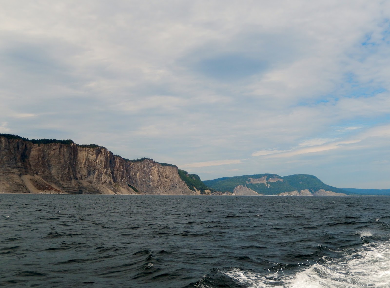
The striking Forillon Peninsula loomed ahead,
with its reddish cliffs plunging straight into the sea it was a dramatic
sight. As if on cue, a whale surfaced nearby!
 |
| Beautiful Sheer Cliffs |
|
 |
| The Forillon Peninsula, the Tip of the Gaspe Peninsula |
 |
| Looking Behind Us |
|
Passing around the flower pot rocks at the
end of the peninsula we could see the light, Cap-de-Gaspe standing sentry above
the cliffs.
 |
| The Tip of the Peninsula |
|
 |
| Cap-de-Gaspe | |
 |
| The Flowerpot Rocks |
The name Gaspe is derived
from the Micmac Indian word, gespeg, meaning “lands’ end”. It clearly is a fitting name. We headed into the Baie de Gaspe and are currently
at Gaspe Town at the head of the bay.
 |
| Club Nautique Jacques Cartier, the Marina at Gaspe Town |
 |
| Gaspe Town |
|


No comments:
Post a Comment